Gifu University, Faculty of Engineering, Dept. of Civil Engineering — Geotechnical & Groundwater Laboratory
TEL. +81-58-293-2421
1-1 Yanagido, Gifu, 501-1193, Japan
Gifu University, Faculty of Engineering, Dept. of Civil Engineering — Geotechnical & Groundwater Laboratory

1-1 Yanagido, Gifu, 501-1193, Japan
Using average soil environment and meteorological data from 120 locations across Gifu Prefecture over a 10-year period (2010–2020), we simulated changes for the mid-term future (2050–2060) and the long-term future (2090–2100).
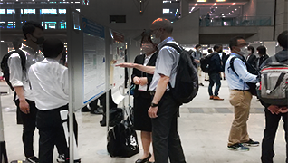
Climate Change Impacts on Soil Moisture and Temperature in the Plain and Mountainous Regions of Gifu Prefecture, Japan
Climate change affects soil environments differently across regions. This study analyzed soil temperature, moisture content, and snow depth in the plains and mountainous areas of Gifu Prefecture using HYDRUS-1D and agrometeorological grid data for 2011–2020 and 2091–2100. Results showed that future soil temperature will rise by 3°C, with greater increases in the plains. Soil moisture will increase in the plains and decrease in the mountains. Differences in snowfall affected moisture content, and soil temperature was more sensitive in the plains while soil moisture was more sensitive in mountainous areas.
Estimating soil hydraulic and thermal properties using publicly available soil information for future prediction of soil temperature and water content
This study examined methods for estimating soil hydraulic and thermal properties required for future predictions of soil moisture and temperature. Using publicly available soil information and pedotransfer functions (PTFs), soil properties estimated by multiple PTFs were compared with data from previous studies, and the method with the smallest error was identified as optimal. Results showed differences in soil temperature and volumetric water content predictions, but little difference in the evaluation of future changes, indicating that publicly available data combined with PTFs can provide valid assessments.
Evaluating the impact of site-specific bias correction of GCM on projection of future soil temperature and moisture: a case study in plain and mountainous regions of Gifu Prefecture, Japan
Projections of soil conditions using general circulation models (GCMs) and soil heat and water transport simulations are ongoing. The accuracy of GCM-based meteorological projections can be improved through site-specific bias correction using local meteorological observations. However, this approach is not feasible in areas lacking weather stations or with limited data. This study examines the impact of site-specific bias correction on future soil condition projections. Bias correction was applied to two GCMs (MIROC5 and MRI-CGCM3) in the plain and mountainous regions of Gifu Prefecture, Japan. Current (2012–2021) and future (2091–2100) soil temperature, volumetric water content, and matric potential were simulated with HYDRUS-1D using both corrected and uncorrected meteorological inputs. Results indicate that site-specific bias correction influenced future soil condition projections, with the magnitude of changes varying by location, GCM type, and soil variable. Maximum monthly variations at 10 cm depth reached 3.8°C, 0.01 m³ m−3 and 257 cm for soil temperature, water content, and matric potential, respectively. However, when focusing on relative changes from current to future conditions, the impact of bias correction diminished. This suggests that, in data-scarce regions, future soil conditions can be estimated without site-specific bias correction by focusing on relative changes.
Development of the “Gifu Prefecture Climate Change Impact Prediction Map” for Spatially Evaluating Climate Change Impacts on Soil Environment
Predicting future soil environments is important for agricultural adaptation to climate change. In this study, we spatially evaluated the impacts of climate change on soil environments in Gifu Prefecture and created the “Gifu Prefecture Climate Change Impact Prediction Map.” Results showed that soil temperature, which is easily influenced by air temperature, increased by approximately 3°C across the entire prefecture. Volumetric water content showed pronounced drying or wetting trends in some areas due to the influence of hydraulic conductivity and wind speed, but overall the prefecture showed a wetting trend, with a maximum increase of 0.004 m³ m−3 expected.
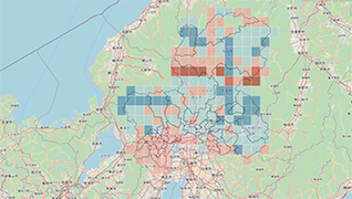
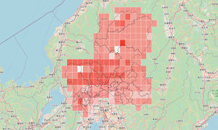
Hydraulic Conductivity · Saturated Volumetric Water Content · Dry Density
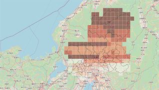
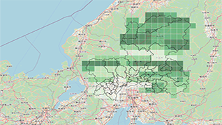
Download the QGIS project file and GeoPackage layers used in this map.
Reference: A Gentle Introduction to GIS
License: CC BY 4.0 · © 2025 Geotechnical & Groundwater Lab, Gifu University
Acknowledgement: This research was supported by the Ogawa Science and Technology Foundation.
Copyright © 2025 · All Rights Reserved · Yuki Kojima, Gifu University